 I’m going to do a more detailed discussion of what the Administration just released as its case to unilaterally and illegally start bombing Syria.
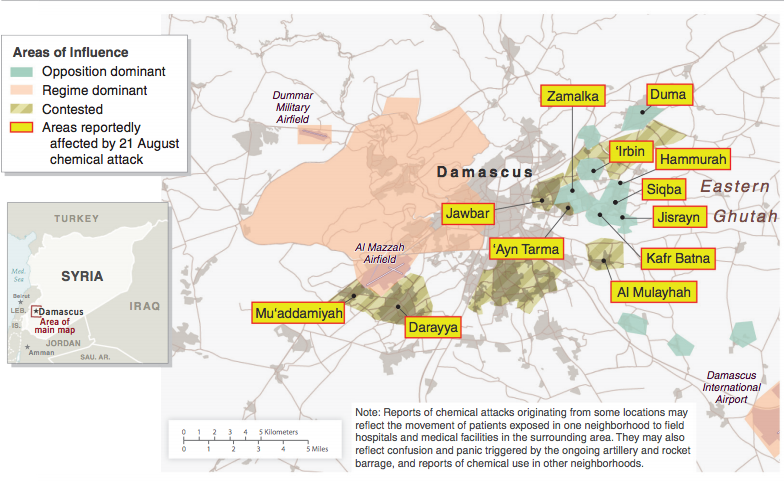
For now, I wanted to point out something that stuck out to me. The map the Administration released — purportedly to show that the location of the strikes were logical Syrian government targets — includes a curious caveat.
Note: Reports of chemical attacks originating from some locations may reflect the movement of patients exposed in one neighborhood to field hospitals and medical facilities in the surrounding area. They may also reflect confusion and panic triggered by the ongoing artillery and rocket barrage, and reports of chemical use in other neighborhoods.
It suggests the US government is uncertain whether these sites are all actual attack sites; it may even reveal USG knows some of these locations may not, in fact, be attack locations.
Remember, the UN inspectors, who are not mentioned at all in the government’s case, will ultimately have forensic evidence from these sites.
All that said, consider how the number and location of sites plays in the case itself.
Local social media reports of a chemical attack in the Damascus suburbs began at 2:30 a.m. local time on August 21. Within the next four hours there were thousands of social media reports on this attack from at least 12 different locations in the Damascus area. Multiple accounts described chemical-filled rockets impacting opposition-controlled areas.
[snip]
We have identified one hundred videos attributed to the attack, many of which show large numbers of bodies exhibiting physical signs consistent with, but not unique to, nerve agent exposure. The reported symptoms of victims included unconsciousness, foaming from the nose and mouth, constricted pupils, rapid heartbeat, and difficulty breathing. Several of the videos show what appear to be numerous fatalities with no visible injuries, which is consistent with death from chemical weapons, and inconsistent with death from small-arms, high-explosive munitions or blister agents. At least 12 locations are portrayed in the publicly available videos, and a sampling of those videos confirmed that some were shot at the general times and locations described in the footage.
We assess the Syrian opposition does not have the capability to fabricate all of the videos, physical symptoms verified by medical personnel and NGOs, and other information associated with this chemical attack.
That is, the USG points to the sheer number of social media reports as proof that the attacks really happened, because the Syrian opposition couldn’t have faked them all.
And yet the USG’s own case suggests that those locations may be inaccurate, even though the locations are portrayed in the videos.
One more note: the government points to satellite imagery showing that attacks from regime controlled areas attacked some — but only some — of the areas in which there were reported attacks.
Satellite detections corroborate that attacks from a regime-controlled area struck neighborhoods where the chemical attacks reportedly occurred – including Kafr Batna, Jawbar, ‘Ayn Tarma, Darayya, and Mu’addamiyah.
That leaves out 7 of the reported attack sites, and only includes one entirely rebel-controlled site: Kafr Batna (taking the map at its word on who controls what).
For the moment, I mean that as nothing more than an observation.